Dear Readers,
While working on Across the Doubtful Sea, the Doubtful Sea series, and a forthcoming series that takes place in an alternate medieval Russia, we discovered for ourselves what our friend J.R.R. Tolkien worked on meticulously during the course of his work—the importance of maps in a story, whether they are real, fictional, or a mixture of both, in the case of our work. “If you’re going to have a story,” he said, “you must work a map; otherwise, you’ll never have a map of it afterwards.”
This became apparent when we were working on Across, using previously drawn maps of the theoretical Terra Australis:


To give us a sense of where our characters and we were (and still are) going.
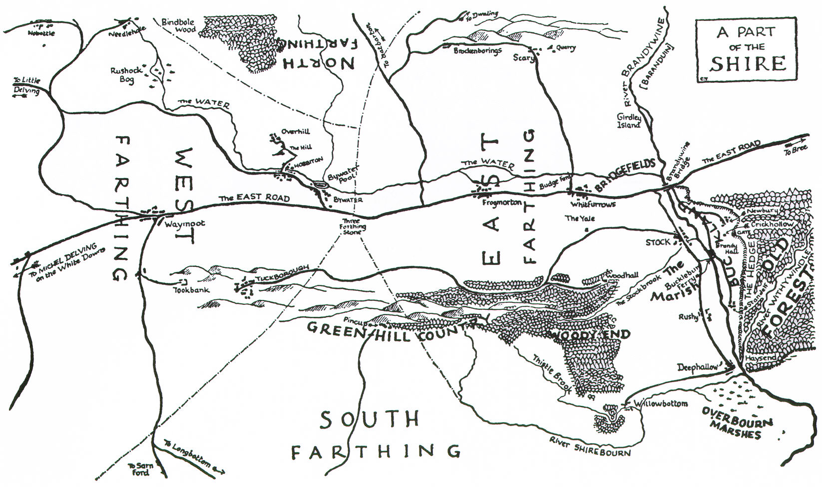
When we began talking about the geography of our alternative Russia, we began to ask ourselves, first, how do you make a map in relation to a story? It was a start to look over the shoulder of JRRT, and to see what was done before us. From there, we go on to ask, what is it that made Middle-earth Middle-earth? It’s clear that Tolkien took a considerable amount of time and care to chart out his elaborate fictional world, from Bilbo’s own maps of the Shire and the world beyond.
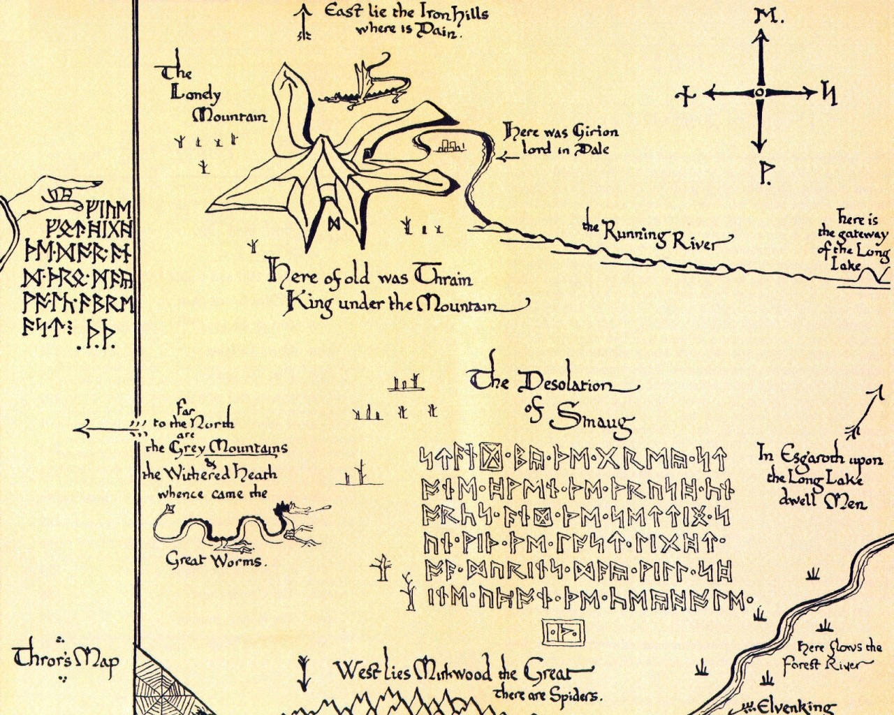
Some were detailed enough to follow the day-by-day travels of the Fellowship, while others were used to record specific moments in time, both historically and geographically.
In his letters, Tolkien often addressed the subject of his maps. Much of his enthusiasm in creating maps for his worlds had to do with the pleasure of doing so, and the satisfaction of building the physical structure of such an elaborate story. He was, however, sometimes overwhelmed by them—perhaps as if the more landscape he made, the more he had to carry—and said to his publisher that it was a matter of a “lack of skill combined with being harried” (Tolkien, letter 141). He was fortunate to have, in this aspect of his work, collaboration not unlike ours—his son, Christopher, was a talented cartographer, and after discussing the landscapes with his father, would draw the intricate world in accordance with Bilbo and Frodo’s adventures.

Tolkien, by creating the maps first, created a landscape which seems to exist not only before the story, but is bigger than the story. When Frodo travels eastwards, for example, there is more of the Shire and beyond than that which he actually travels over. In our case, it was rather like someone laying track while driving a train over it. The tracklayer decides where the train will go, but, looking back, can see a landscape left behind as it moves on. In this way, the story and its landscape are written as they progress, and a narrative railroad is left behind on which readers may ride. And so, unlike Tolkien, by constructing a map this way, we appear to be providing primarily a view from the track itself. If there’s more landscape, we can only know it from the map we’ve constructed afterwards.
With the previously-drawn map, we can see the journey, in contrast, from a bird’s eye view.
But this leaves us with a question: is it best to construct a bird’s eye view first, then to lay the track, or to lay track and then to look back?
This brings us to a second question: by either method, how does one make a fictional map credible?
MTCIDC,
CD
PS
For an example of simultaneous train-driving and track-laying, see Wallace and Gromit, The Wrong Trousers.
