Welcome, dear readers, as ever.
We’ve often written about earlier English worlds and how they influenced Tolkien’s depiction—often, his basic imagining—of Middle-earth. When it comes to Roman influence, we once posted an essay about the Rammas Echor—the great wall surrounding the Pelennor, the fields below Minas Tirith—and the possible use of Hadrian’s Wall in northern Britain as a model (“Where Did It Go—And Why?” 17 June, 2015)

At another time, we devoted a posting to the subject of Roman roads and those of Middle-earth (see “The Road (No Longer) Taken”, 21st September, 2016). When it comes to the actual Roman roads, there is a lot of really interesting discussion about their survival and use in Britain after the last troops were pulled out in 410AD. One theory is that, although the roads continued in service, perhaps for centuries, Roman bridges began to collapse in time and, when they did, new routes to fords began to appear and gradually supplanted at least some of the old roads.

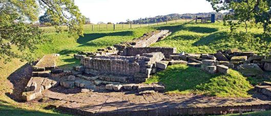
This is a fairly recent theory, but Tolkien appears to have come to the same conclusion years before as we see in his description of a great city which had once stood on that North-South Road, Tharbad, and its bridge over the river Greyflood—Gwathlo:
“…both kingdoms shared an interest in this region, and together built and maintained the Bridge of Tharbad and the long causeways that carried the road…When Boromir made his great journey from Gondor to Rivendell…the North-South Road no longer existed except for the crumbling remains of the causeways, by which a hazardous approach to Tharbad might be achieved, only to find ruins on dwindling mounds, and a dangerous ford formed by the ruins of the bridge…” (Unfinished Tales, 277)
Before the return of the King, then, it appears that travel within whole sections of Middle-earth had almost dried up:
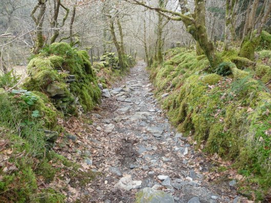
“But the Northern Lands had long been desolate, and the North Road was seldom used: it was grass-grown, and the Bree-folk called it the Greenway.” (The Fellowship of the Ring, Book One, Chapter 9, “At the Sign of the Prancing Pony”)
We’ve always visualized the North Road,

when it was in general use, as looking like a Roman road, when it was in use: laid out directly across the countryside, carefully built, fitted with flat stone on multiple layers of smaller stone and gravel.
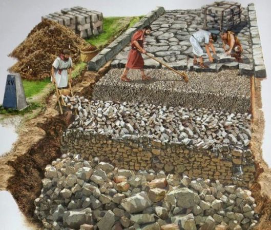

And we can also then see the Greenway as looking like a Roman road when that went out of use.
The Romans had used their roads as direct passage for troops,

but there was a commercial use, as well,
and it seems natural that, long after the Romans had left, or become part of the general Romano-British (or Sub-Roman) population, those paved, straight roads were still a part of the transport/trade system, and maybe for a long time beyond.
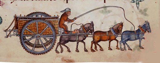
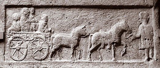
(And, yes, that is a monkey driving that cart. This is from one of our favorite illuminated manuscripts, the Luttrell Psalter, from the mid-14th century. If you’d like to learn more about it, here’s a LINK: https://www.bl.uk/collection-items/the-luttrell-psalter )
From the talk in The Prancing Pony, however, it appears that about the only people using the road at the time of the War of the Ring were refugees:
“There was trouble away in the South, and it seemed that the Men who had come up the Greenway were on the move, looking for lands where they could find some peace.” (The Fellowship of the Ring, Book One, Chapter 9, “At the Sign of the Prancing Pony”)
As we said above, we’ve very often written about past Britain and how it may have influenced Tolkien’s Middle-earth. JRRT is wonderfully creative in what he uses, everything from clothing and weapons to manuscripts and architecture. In our last posting, however, we thought that it might be interesting to look at something common in our medieval “Middle Earth” which doesn’t turn up in Tolkien’s. Our first choice was churches. As JRRT wrote in a footnote to a 1954 letter which we quoted in our last posting: “There are thus no temples or ‘churches’ or fanes in this ‘world’ among ‘good’ peoples.” (Letters, 193) In that posting, we used a mid-16th-century image of London to illustrate just how common such buildings (and what went on inside them) were in our Middle Earth.

As you can see, everywhere you look, there are church towers and steeples. This is the biggest city in the kingdom at the time, of course, but, across the countryside, in virtually every village, there was a church. In fact, in places where there might not be a church itself, there was a chapel-of-ease, a separate little building which could serve as one.
Those churches, along with what Tolkien calls “fanes”, which means shrines (religious sites, but not necessarily in churches), were sometimes more than often-impressive buildings and the services held within them. They could also be a major reason for medieval people, thousands of them, to be on what roads there were, not only in Britain, but across Europe. As they are attached to medieval religious life, about which we talked in our last posting, we thought that we’d add them to it as a sort of ps.

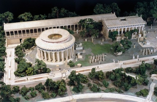
Centuries before the Romans built their roads, people had made journeys, sometimes long journeys, to religious sites in the western world, usually either to hear about their future from the lips of a god, at places like Delphi,
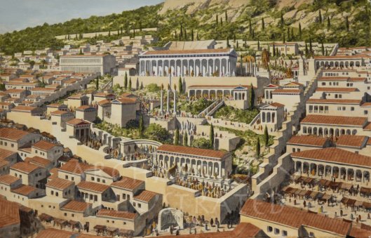
where the priestess of Apollo told you in verse something which might please or frighten you,
or to look for a cure, at shrines like Epidauros, for what ailed them.
With the gradual change from the classical to the early medieval world, people continued to make such journeys, but now, instead of traveling to shrines dedicated to various ancient gods, people visited Christian shrines, like Jerusalem

or Rome.
Finding out about the future was no longer an option, but people certainly traveled to find cures and this is where our title comes in. It’s taken from the “General Prologue” to Geoffrey Chaucer’s (c.1340s-1400)
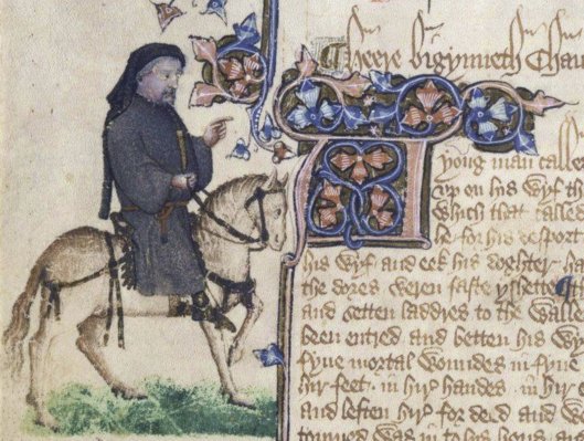
The Canterbury Tales, a collection of stories, almost entirely in verse, told by a group of travelers on their way to the medieval shrine of Canterbury, as Chaucer explains (that, in April):
“…Thanne longen folk to goon on pilgrimages,
And palmeres for to seken straunge strondes,
To ferne halwes, kowthe in sondry londes;
And specially from every shires ende
Of Engelonde to Caunterbury they wende
The hooly blisful martir for to seke,
That hem hath holpen when that they were seeke.”
That “hooly, blissful martir” was Thomas Becket (1119-1170), Archbishop of Canterbury,
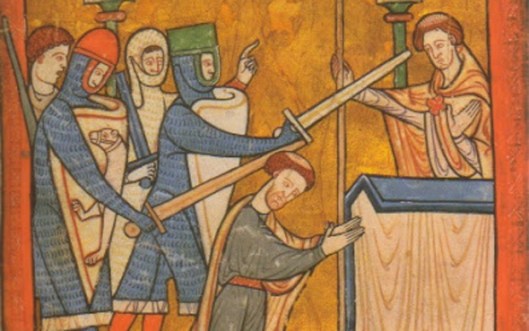
who was murdered in his own cathedral by 4 knights possibly sent by his one-time friend, Henry II.
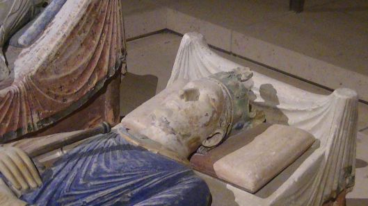
Becket’s tomb

(this is a more modern version—the original was destroyed during the period when Henry VIII was taking over the churches and monasteries and appointing himself head of a new English Church in the 1530s) had quickly gained a reputation for wonder-working and therefore drew people like Chaucer’s pilgrims.

To reach Canterbury, they traveled southeast, along the southern side of the Thames, and the road on which they traveled, shown on this map as “Watling Street”,
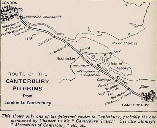
was an ancient track, but was later converted into a paved road by the Romans to provide easier access to their southeast coastal ports—and clearly still in use nearly a thousand years after the departure of the pavers.
Canterbury was hardly the only such shrine in England. People also traveled to churches and shrines at Walsingham, Holywell, Glastonbury, Winchester, Durham, and St Alban’s, among many other places, sometimes along the same roads the Romans had built, like Watling Street, and sometimes on later medieval ones.

But if you saw a group of pilgrims, or even one, on the road, what would tell you what you were looking at? The answer is a souvenir.

This is a medieval pilgrim’s badge, cast from lead and sold at the site. You purchased this at the church or shrine, pinned it on your hat or clothing, and it told anyone you met that you’d made a journey to a religious location. They could be very specific to a shrine. This one, in fact, might have been attached to Chaucer’s cloak or hat, as it comes from Canterbury and has an idealized image of Archbishop Becket on it to prove it. (For more on pilgrims’ badges, see this LINK: https://collections.museumoflondon.org.uk/online/group/19998.html for the Museum of London, an absolute treasure house of British history.)
In Tolkien’s extensive letter of 1954, cited above, he mentions the lack of religious places in Middle-earth, but says only in explanation that, “They had little or no ‘religion’ in the sense of worship.” and that “this is a ‘primitive age’”, although judging by its great antiquity and the complexity of the civilization which has survived so much turmoil in its struggles, particularly with Sauron, we find that a little hard to understand. We wonder, however, thinking of his wonderful ability to create new from old, what Tolkien would have given us, had he used not only the religious buildings, but the customs, including pilgrimage, of the medieval English world as models, in his Middle-earth? Imagine Butterbur, at the Prancing Pony, telling the hobbits that:
“There’s a party that came up the Greenway from down South last night and then there’s a travelling company of dwarves going West come in this evening, and then there’s that troop of pilgrims on their way to the shrine of St Amandil the Numenorean…”
Thanks, as ever, for reading. Stay well and know that there will be
MTCIDC
CD
ps
If you know us, you know that we can never resist a temptation to add something more. When we were doing a little research on pilgrimage in England, we came across what is now thought to be the oldest medieval map of Britain. It’s called the “Gough Map”, after its last owner, who donated it to the Bodleian Library at Oxford in 1809, and dates probably from the mid-14th century (but may be based upon an older map yet).

Going one step farther, we came upon a BBC documentary series entitled “In Search of Medieval Britain”, hosted by a medieval art historian, Alixe Bovey, which follows the map to explore various parts of medieval Britain, which we thought was a brilliant idea. We very much enjoyed the series and so we post this LINK to the first episode, in case you’d like to see it for yourself: https://www.youtube.com/results?search_query=in+search+of+medieval+britain+episode+1
